Walks ending at Hawes 6th July 2025
The A walk will be led by Glynis and is approximately 12 ½ miles and 1750 feet of gradual ascent.
Beginning in Hawes we will head towards Hardraw, joining the Pennine Way and continuing to climb steadily to the top of Great Shunner Fell which is the third highest mountain in the Yorkshire Dales. The track to the top is good with fabulous views and hopefully the hay meadows will still be covered with summer flowers. Highlights of the panorama from the top are Swaledale with its green fields and Wild Boar Fell to the West. From the summit we follow the fence to reach Little Shunner Fell and eventually join the Butter Tubs road. There is a good grassy verge to walk along for much of this road and we will come down to Shaw Gill Wood, passing waterfalls and crossing fields to return to Hardraw and back into Hawes.
The B walk will be led by Paul and is approximately 8 miles and 1500 feet of ascent.
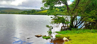
We start with a small but steady rise out of Bainbridge, followed by easy paths to Semer Water.
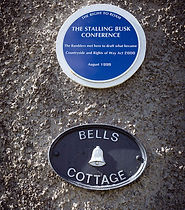
We will go up to Stalling Busk village where there is an item of interest for rambling history, then
down to Marsett, an attractive and really old-fashioned farming settlement. The main climb starts
after that, some 900ft to near the summit of Wether Fell - there will be plenty of stops to admire
the view of Semer Water! Then it is grassy paths back down into Gayle and Hawes. The climb up
Wether Fell aside, the walk is pretty gentle.
The C walk will be led by Bob and is approximately 4.9 miles with 800 ft of ascent.
The starting point which is a mile before Hawes, is already at 1000 ft, so we get quite high, with good open views over Wensleydale, with minimal effort. Almost all of the walk is on very easy tracks with gentle slopes. We follow Cam Road uphill for 2 miles to Ten End, the highest point at 1800 ft, then follow the Pennine Way down to the attractive village of Gayle and into Hawes. Just before Gayle we have the possibility of a diversion alongside Gayle Beck to visit Aysgill Force, which would add a mile or so to the distance with no significant ascent.