Walks ending at Langdale 7th June 2026
The A walk will be led by Andy and is approximately 8 miles and 2700 feet.
Bowfell at 2959 feet is the sixth highest mountain in the Lake District and was described by Alfred Wainwright as one of “best half dozen” with its wonderful panoramic views including Scarfell Pike and Scarfell. The walk will start from the New Dungeon Ghyll and head towards Oxendale where we pick up the path going up the ridge known as The Band which takes us to a col known as Three Tarns. From there it is a rocky path to the summit. We will return to the new Dungeon Ghyll via the same route. This not only avoids some alternative arduous paths back, but the views coming down The Band are even better than going up with superlative views of the Langdale Pikes and Great Langdale stretching out before us.
The B walk will be led by John and is approximately 8 miles and 1700 feet(highest point at 1295ft)
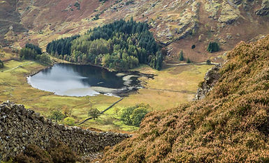
A linear walk, the route starts from Elterwater where we cross Great Langdale Beck and join the Cumbria Way. Walking in a north westerly direction to Chapel Stile and eventually onto a path above Great Langdale Campsite. From here we turn southwards and start our ascent to the lane adjacent to Side Pike, we follow the lane for a short distance and then turn to ascend by the east of Side Pike. We continue onto Lingmoor Fell, where the path is less visible through low lying heather and finish at the remote Lingmoor Tarn. We then retrace our steps descending back down to the campsite and onto Old Dungeon Ghyll and finally to New Dungeon Ghyll.
The C walk will be led by Phil and is 5.8 miles and 500 feet.
The walk starts at Dungeon Ghyll and follows the Cumbria Way up past Side House to Oak Howe and then the lane to Baysbrown Farm and the quiet road steadily uphill to Sawreys Wood. We descend through the quarry to rejoin the Cumbria Way past Chapel Stile and alongside the campsite before crossing the beck and taking the good path back to the start.

Bowfell